Mobility Insight

Detect, understand and fix mobility issues

By combining multi-source data fusion with AI-driven data analysis (forecasting, impact analysis, anomaly detection), Kentyou Mobility Insight enables municipalities to detect disruptions earlier and anticipate their consequences without becoming overwhelmed by detail.

Mobility Insight platform: Istanbul traffic map with junction details, speed, occupancy and volume

Overwhelmed by fragmented data, still missing the big picture

Cities generate enormous volumes of mobility data every day, but it stays fragmented across independent systems, each providing a partial view of the network. Operators watch dozens of screens to detect incidents, and engineers consolidate historical data by hand to understand mobility patterns and evaluate infrastructure projects.


Built for

Traffic operatorsTraffic engineersMobility plannersDecision makers

What sets it apart

Prioritized insights, not more dashboards

Instead of overwhelming users with dashboards and raw data, Mobility Insight delivers prioritized insights, so operators and planners focus on the situations that matter most.

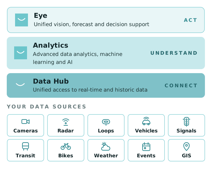
The platform seamlessly integrates heterogeneous data from traffic cameras, radar sensors, magnetic loops, Floating Car Data, public transport systems, weather forecasts, GIS, and existing traffic management systems into a unified operational view.

Mobility Insight announcements history for a junction: maintenance and vehicle breakdown notices

What you gain

Act on the situations that matter

01

Improved traffic flow

Reduce congestion and optimize road use with real-time monitoring and predictive insights.

02

Faster incident response

Disruptions are detected early, impacts are analyzed, alerts are sent along with actionable insights.

03

Lower monitoring effort

Operators can focus on problems and situations that need immediate intervention.

04

Better planning

Engineers move from descriptive reporting to predictive and prescriptive planning.

05

Lower emissions and costs

Better flow cuts emissions; targeted upgrades and optimized fleets save money.

06

Greater satisfaction for citizens

Smoother traffic and better public transport.


Technical innovation

How it works

01

Multi-source data fusion

Cameras, radar sensors, magnetic loops, connected-vehicle data, public transport, weather and GIS in one operational view.

02

Correlation and impact analysis

Reveals links between independent mobility systems and the effect of an event across the network.

03

Abnormality detection and forecasting

Abnormal traffic spotted in real time, with forecasts of traffic evolution and mobility demand.

04

Multi-criteria optimization

Operational and planning decisions that weigh several objectives.

How Kentyou Mobility Insight works: Data Hub connects, Analytics understands, Eye acts, on top of your mobility data sources

Main features

What it offers today

Connected data sources

Cameras, road sensors, public transport and soft mobility, linked to existing city tools.

Interactive maps

Multi-layered views of the network for informed decision making.

Real-time disruption detection

Patterns, bottlenecks, impact analysis and mobility trends.

Traffic forecasts

Anticipate traffic trends and act before issues arise.

Mobility services usage

Analyse how mobility services are used to improve citizen’s quality of life.

Custom indicators

Customizable performance indicators for strategic planning and impact monitoring.


Explore our other solutions


Talk to our team

Questions about our products, services or partnerships? We are always looking to strengthen our impact in smart cities by joining forces.

Contact us